


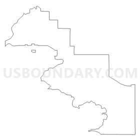
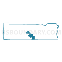
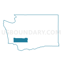
Harmony Voting District, Lewis County, Washington
About
Outline
Summary
| Unique Area Identifier | 687478 |
| Name | Harmony Voting District |
| County | Lewis County |
| State | Washington |
| Area (square miles) | 78.96 |
| Land Area (square miles) | 68.40 |
| Water Area (square miles) | 10.56 |
| % of Land Area | 86.63 |
| % of Water Area | 13.37 |
| Latitude of the Internal Point | 46.48341390 |
| Longtitude of the Internal Point | -122.37917230 |
Maps

Graphs
Select a template below for downloading or customizing gragh for Harmony Voting District, Lewis County, Washington


Neighbors
Neighoring Voting District (by Name) Neighboring Voting District on the Map
- Cinebar Voting District, Lewis County, WA
- Klickitat Voting District, Lewis County, WA
- Lewis River Voting District, Skamania County, WA
- Mossyrock Voting District, Lewis County, WA
- Rose Valley Voting District, Cowlitz County, WA
- Salkum Voting District, Lewis County, WA
- Silver Creek Voting District, Lewis County, WA
- Temple Voting District, Lewis County, WA
- Toutle Voting District, Cowlitz County, WA
- Verndale Voting District, Lewis County, WA
Top 10 Neighboring County Subdivision (by Population) Neighboring County Subdivision on the Map
- Mossyrock CCD, Lewis County, WA (4,652)
- Mineral CCD, Lewis County, WA (4,175)
- Morton CCD, Lewis County, WA (2,931)
- Northeast Cowlitz CCD, Cowlitz County, WA (1,689)
- North Skamania CCD, Skamania County, WA (98)
Top 10 Neighboring Place (by Population) Neighboring Place on the Map
Top 10 Neighboring Unified School District (by Population) Neighboring Unified School District on the Map
- Kelso School District, WA (28,482)
- Stevenson-Carson School District, WA (6,199)
- Onalaska School District, WA (5,293)
- White Pass School District, WA (4,080)
- Mossyrock School District, WA (3,994)
- Toutle Lake School District, WA (3,348)
- Morton School District, WA (2,742)
Top 10 Neighboring State Legislative District Lower Chamber (by Population) Neighboring State Legislative District Lower Chamber on the Map
- State House District 18, WA (160,083)
- State House District 20, WA (141,029)
- State House District 15, WA (132,788)
Top 10 Neighboring State Legislative District Upper Chamber (by Population) Neighboring State Legislative District Upper Chamber on the Map
- State Senate District 18, WA (160,083)
- State Senate District 20, WA (141,029)
- State Senate District 15, WA (132,788)
Top 10 Neighboring 111th Congressional District (by Population) Neighboring 111th Congressional District on the Map
Top 10 Neighboring Census Tract (by Population) Neighboring Census Tract on the Map
- Census Tract 9717, Lewis County, WA (4,652)
- Census Tract 9718, Lewis County, WA (4,175)
- Census Tract 9719, Lewis County, WA (2,931)
- Census Tract 18, Cowlitz County, WA (1,689)
- Census Tract 9501, Skamania County, WA (98)